
Monday, October 26, 2009
Bandarawela
History
History of the Bandarawela area is coming from the time of great Sinhalese King Valagamba who fell back and regrouped in the Dhowa region to fight against Chola invaders.
During the period of British colonial era, the city occurred rapid development of the infrastructures and human resources due to tea plantations and migration of the British and local people to this area. A lot of past evidences can be seen there belongs to that colonial period. There is few buildings remain which were built in the British colonial period with British architectural influences such as Bandarawela Hotel,Cargiles building, Tennis club, etc.
Bandarawela is one of the Sinhalese majority territories in Sri Lanka before the establishment of tea plantations under British administration. Nowadays there is a mix culture due to the migration of Tamils to the tea plantation sector as laborers from India under British colonial times. Those Tamil community had been got their full citizenship during the UNP Government period in 1978 to 1988 by Affidavit Act no 39 of 1988 [1]. The records of the other ethnic groups in this area are negligible.
Bandarawela famous as having been the camp in Ceylon of the Boer prisoners of war and some of the buildings erected for the temporary accommodation of the captives are now used in connection with the permanent camp health recuperation established here for the Navy , military and volunteers.
[edit] Politics
The town is ruled by a urban council headed by a mayor. The council is elected by popular vote and has 9 seats. There were 4,147 registered voters in the 2006 local authorities elections [2]. The urban council has been governed by the United National Party one of the largest political parties in Sri Lanka.
Out side the urban area is governed by the "Pradeshiya" saba which is also similar to the urban council. The pradeshiya saba is elected by popular vote as well and it has 10 seats. In the 2006 local authorities election, 37,972 voters were registered for the election.[3]
[edit] Heritage
The main heritage sites in and around Bandarawela are ancient Dhowa Buddhist rock temple,the Roman Catholic Church- St. Anthony's Church and Methodist church. Ancient dhowa rock temple was founded by the King Walagamba in the first century BC which is located 6 km away from the Bandarawela city. It has a 38 ft Buddha image sculptured from a rock and some paintings belonging to the Kandyan era, depicting various Jataka stories.
[edit] Geography and Climate
During colonial times, the picturesque town of Bandarawela was once hailed as possessing one of the healthiest climates in the world, & nothing much has happened here to change that. Therein this was the most favourable climate in the island. Geographically, the Bandarawela area is hilly and surrounded by the large number of mountains in Uva and Central Province.
According to the local climatic zone classifications, Bandarawela is classified under Up Country Intermediate Zone (UCIZ) which is spread over the Badulla and Moneragala Districts. The elevation above the sea level at Bandarawela is 1300 m, the annual average rainfall is between 1100 and 1400 mm and the monthly average temperature are between 15 °C (in February) and 27 °C (in May and June). The Bandarawela area consists mainly at Red Yellow Podzolic soil which is strongly acidic and favorable for the tea plantation.
[edit] Demography
Bandarawela is a Sinhala majority city, there are sizeable communities belonging to other ethnic groups, such as Indian Tamils, Sri Lanka Moors and Sri Lanka Tamils.
No Ethnicity Population % Of Total
1 Sinhala 46,843 72.42
2 Indian Tamils 10,521 16.26
3 Sri Lankan Tamils 3,647 5.63
4 Moors 3,127 4.83
5 Malays 267 0.41
6 Burghers 147 0.22
7 Other 123 0.19
Total 64,675 100
[edit] Religion
Bandarawela area has multi religious population. Buddhism and Hinduism constitute majority of the religious faith. There is also a minority of Islams and Catholics. Pushparama Buddhist temple, Sri Sivasubramania Swamy Kovil and Masjid Mohideen Muslim mosque are the main religious places situated in and around Bandarawela Urban area. There is also three catholic churches which has long historical background with colonial periods situated very close to the city.
Bandarawela religiosity
religion percent
Buddhism
70.92%
Hinduism
18.31%
Islam
5.44%
Roman catholic
4.13%
Other Christians
1.15%
other
0.02%
[edit] Economy
The main livelihood of the people living in this area is agriculture farming and tea plantation. Majority of the people are directly involved in vegetable cultivation and some are working as laborers in tea estates. There are large number of tea plantations which are managed by both private and government sectors and produce good quality tea for the world tea market.
Although Vegetable gardens also used to be a common sight around the town. A lot of temperate vegetables are grown in this area throughout the year such as leek, carrot, beet root, cauliflower, cabbage and more. About one tenth of the population works for government, private establishments and run their own businesses. So the majority of the people in this area fall in the low and middle income groups.
Tourism is another income generation way in bandarawela area. A lots of holiday resorts, cottages and hotels can be found in this area with better facilities.
[edit] Education
During World War II, many families moved to Bandarawela as leading schools in Colombo such as Royal College, St. Thomas' College and Visakha Vidyalaya, completely shifted to Bandarawela due to the fear caused by the Japanese bombs. This caused to improve the education background of the people in Bandarawela. Bandarawela has good education background to generate intelligent people for the country's development. It consists of many popular schools in the Badulla district with better facilities for primary and secondary education. Some of schools in the area include Bandarawela Central college, Visakha Vidyalaya, Little Flower Convent and St. Joseph college Bandarawela. These schools are governed by the central government of Sri Lanka. There are also two private schools which are popular in island wide. They are S. Thomas' College Bandarawela and S. Thomas' College,Guruthalawa.
[edit] Picturesque Places
Front view of the Adisham Bangalow
Rawana Ella (131ft in height) and Diyaluma (628ft in height) are the most beautiful waterfalls in this region. Rawana ella is situated on the Ella, Wellawaya main road and Diyaluma situated near the Koslanda village. Adisham bungalow, Bandarawela hotel and Lipton's Seats are other historic places in Bandarawela area. Bandarawela hotel is a century old British built property associated with the development of the hill-country railways.
Adam's Peak
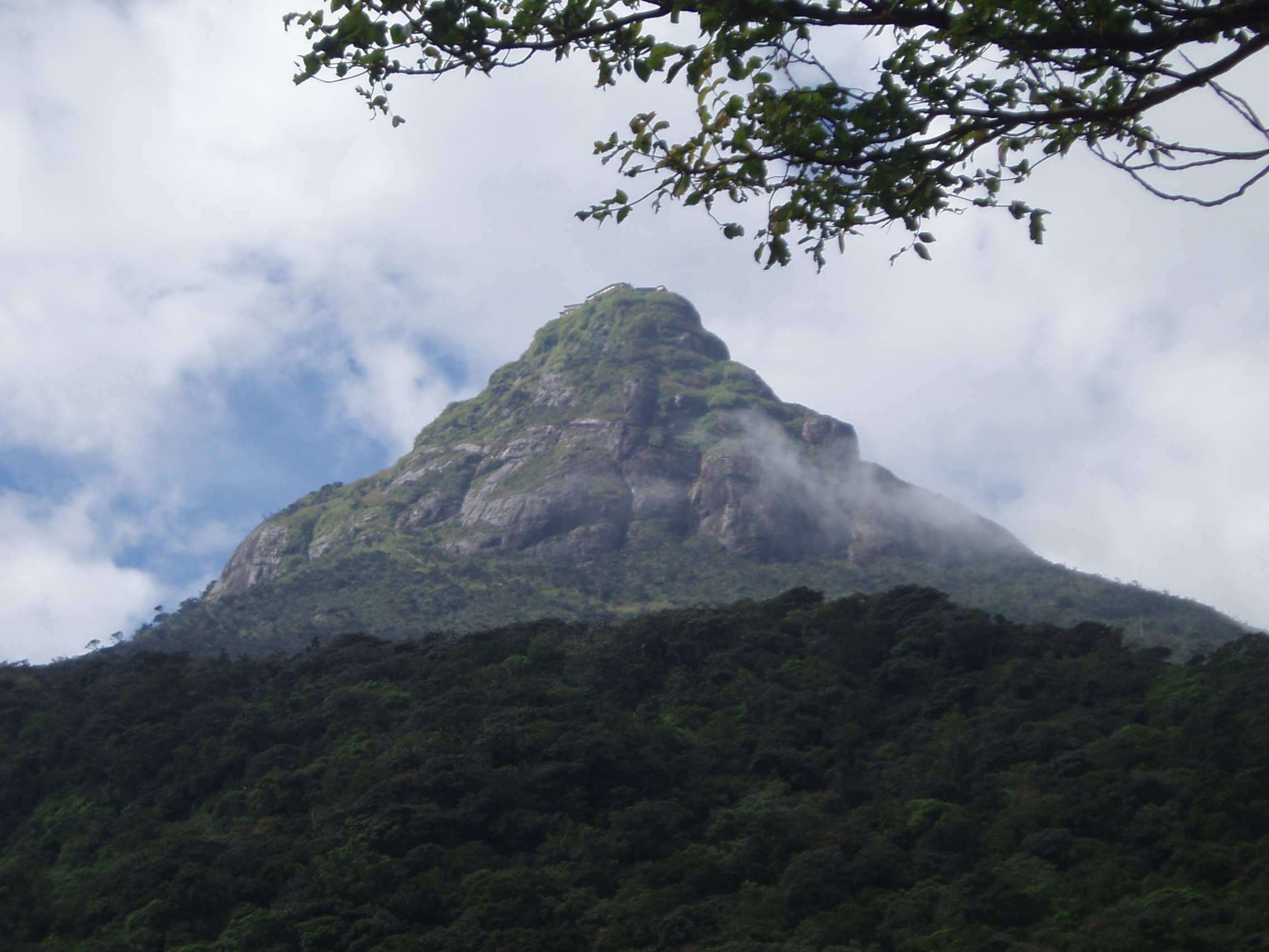
Geography
The mountain is located in the southern reaches of the Central Highlands, in the Ratnapura district of the Sabaragamuwa Province - lying about 40 km northeast of the city of Ratnapura. The surrounding region is largely forested hills, with no mountain of comparable size nearby. The region along the mountain is a wildlife reserve housing many species varying from elephants to leopards, and including many endemic species.
Access to the mountain is possible by 6 routes (Ratnapura-Palabaddala, Hatton-Nallathanni, Kuruwita-Erathna, Murraywatte, Mookuwatte & Malimboda). Out of these the Nallathanni & Palabaddala routes are the most popular. Kuruwita-Erathna road is somewhat popular as well. The other 3 roads are almost obscure. It joins the Palabaddala road midway through the ascent. Buses connect the final nodes of Nallanthanni to Hatton, Palabaddala to Ratnapura & Erathna to Kuruwita. There after it's a difficult journey through the forest on foot.
[edit] Nomenclature
Sunrise on Adam's Peak
Due to its historical significance to the various peoples that inhabit the region, the mountain, itself, is referred to by a variety of terms.
Sri Pada is the term, derived from Sanskrit, used by the Sinhalese people in a religious context. This name is also understood in Pāli, and may be translated roughly as "the sacred foot". It refers to the footprint-shaped mark at the summit, which is believed by Buddhists to be that of the Buddha. Other traditions assert that it is the footprint of Adam, left by his first entrance into the world.
Shivanolipatha Malai and Shiva padam are two Tamil names holding similar meanings, but both refer to the footprint as being that of the Hindu deity Shiva rather than that of the Buddha.
The Sinhala name of the mountain is Samanalakanda, which refers either to the deity Saman, who is said to live upon the mountain, or to the butterflies (samanalayā) that frequent the mountain during their annual migrations to the region.
Other local and historic names include Ratnagiri ("jewelled hill"), Samantakuta ("Peak of Saman"), Svargarohanam ("the climb to heaven"), Mount Rohana and other variations on the root Rohana.
[edit] The Sacred Mountain
The shadow on the Western side
The village of Maskeliya at the feet of the mountain, where the stairs begin
It is revered as a holy site by Buddhists, Hindus, and to a lesser extent by Muslims and Christians. It has specific qualities that cause it to stand out and be noticed; including its dominant and outstanding profile, and the boulder at the peak that contains an indentation resembling a footprint. As the 1910, Encyclopædia Britannica notes[1]
For a long period Adam's Peak was supposed to be the highest mountain in Ceylon, but actual survey makes it only 7353 ft. above sea-level. This elevation is chiefly remarkable as the resort of pilgrims from all parts of the East. The hollow in the lofty rock that crowns the summit is said by the Brahmans to be the footstep of Siva, by the Buddhists of Buddha, by the Muslims of Adam, whilst the Portuguese Christians were divided between the conflicting claims of St Thomas and the eunuch of Candace, queen of Ethiopia. The footstep is covered by a handsome roof, and is guarded by the priests of a rich monastery half-way up the mountain, who maintain a shrine on the summit of the peak.
It is an important pilgrimage site, especially for Hindus and Buddhists. Pilgrims walk up the mountain, following a variety of routes up thousands of steps. The journey takes several hours at least. The peak pilgrimage season is in April, and the goal is to be on top of the mountain at sunrise, when the distinctive shape of the mountain casts a triangular shadow on the surrounding plain and can be seen to move quickly downward as the sun rises.
Climbing at night can be a remarkable experience, with the lights of the path leading up and into the stars overhead. There are rest stops along the way.
[edit] Legends
The mountain is most often scaled from December to May. During other months it is hard to climb the mountain due to very heavy rain, extreme wind, and thick mist.
Buddhists say that the footprint mark is the left foot of the Buddha, left behind as he strode away, the right footprint being (depending on legend) in Amphoe Phra Phutthabat, Saraburi Province, located about 150 kilometres northeast of Bangkok, Thailand. This place is called in Thai Phra Bat or Phra Phutthabat.
Tamil Hindus think it is the footprint of Shiva.
Muslims and Christians in Sri Lanka ascribe it to where Adam, the first Ancestor, set foot as he was exiled from the Garden of Eden. The legends of Adam are connected to the idea that Sri Lanka was the original Eden.
A shrine to Saman, a Buddhist "deity" (People who have done yeoman service to regions are deified by Sri Lankan Buddhists) charged with protecting the mountain top, can be found near the footprint.
List of historical elephants.
List of historical elephants.
* Abul-Abbas - Charlemagne's elephant
* the Cremona elephant, given to Holy Roman Emperor Frederick II by the Sultan of Egypt in 1229.
* Annabelle the painting elephant - was an Indian elephant won in a contest, donated to be Anchorage, Alaska's Alaskan Zoo's first animal in 1964.
* Black Diamond - Indian elephant with Al G. Barnes Circus, killed four people and was subsequently shot in 1929.
* Batyr (1970-93) - the talking elephant of Karaganda Zoo in Kazakhstan.
* Castor and Pollux - served up to the wealthy citizens of Paris during the siege in 1870.
* Chunee - an elephant in the menagerie at Exeter Exchange, executed by soldiers from Somerset House in March 1826
* Hannibal's war elephants - In 218 BC, Hannibal crossed the Alps with 37 elephants in the Second Punic War. Surus (the Syrian) is mentioned as the bravest elephant in the army by Marcus Porcius Cato, the elder in his book Origines.
* Hanno the elephant - pet elephant of Pope Leo X
* Hansken - toured many European countries from 1637 to 1655 demonstrating circus tricks
* Hattie (elephant) of New York City's Central Park Zoo that in 1903 was described as the "most intelligent of all elephants"[1]
* John L. Sullivan (Elephant) (1860 ? - 1932) - the famous boxing elephant in Adam Forepaugh's circus. In 1922, he made a pilgrimage from Madison Square Garden to the Elephant Hotel in Somers, New York to pay tribute to Old Bet.
* Jumbo - P. T. Barnum's elephant whose name is the origin of the word "Jumbo" meaning "very large" or "over-sized." The African-Elephant was given the name Jumbo by zookeepers at the London Zoo. The name was most likely derived from the Swahili word "Jumbe" meaning "chief."
* Jumbo - The Elephant John Hoyte et al. used to cross the alps in 1959 to retrace Hannibal's march across the Alps.
* Betty the Learned Elephant- Third elephant and first trained elephant in the United States. After her owner claimed that even bullets couldn't pierce her hide, she was shot by local men in Chepachet, RI on May 25, 1826.
* Fanny the elephant- a former circus elephant she resided in Slater Park Zoo in Pawtucket, RI from 1958-93. She was moved to the Cleveland Amory Black Beauty Ranch sanctuary in 1993 because the city closed the zoo exhibits due to financial crises. She lived the last 10 years of her life happily and died in 2003. A statue to her memory stands in Slater Park.
* Kandula - the most famous elephant in Sri Lanka was given to an infant prince Dutugemunu (or Dushtagamini) in the 2nd century BC. The king and his elephant grew up together. A Sri Lankan elephant born November 25, 2001, at the National Zoo in Washington D.C. is named after Kandula.
* Kesavan - an Indian elephant, which was associated with the Guruvayur temple in Kerala, India. The elephant was known for its extreme devout behaviour.
* The Kilimanjaro Elephant - It is thought, but not known, that he was killed on the northern slopes of Mount Kilimanjaro in 1898. His tusks weighed 237 and 225 pounds, and no other tusk in history ever went over 190 pounds. The British Museum of Natural History bought the pair of them in 1932, and after an attempt was made to steal them in 1937, they were taken off exhibit. Each are more than ten feet long and two feet in circumference at the base. Inspiration for Mike Resnick's book "Ivory: A Legend of Past and Future."
* Lallah Rookh - an elephant with Dan Rice's circus. She died in 1860 soon after swimming across the Ohio River.
* Lin Wang - a Burmese elephant that served with the Chinese Expeditionary Force during the Sino-Japanese War (1937-1945) and later moved to Taiwan with the Kuomintang army. Lin Wang became a fond childhood memory among many Taiwanese.
* Mahmoud - the lead elephant in the army of Abraha, which attacked the Kaaba in Mecca. Thus, the year became known as the Year of the Elephant and provided a historical ready-reference for the birth date of the prophet of the Muslim religion, Muhammad.
* Mamie - African elephant at the Knoxville Zoo who painted. She died March 10, 2006 at 45 years old.
* Mary a.k.a. "Mighty Mary" and "Murderous Mary" - executed on September 13, 1916 in Erwin, Tennessee. She was hanged by a railroad derrick car at the Clinchfield Railroad yard. This is the only known elephant hanging in history. Mary, who toured with the Sparks World Famous Shows circus, killed her inexperienced keeper, Walter "Red" Eldridge, on September 12, 1916 during a circus parade in Kingsport, Tennessee. Eldridge had supposedly hit Mary's tusk or ear when she wandered from the parade line to eat a piece of discarded watermelon.
* Mona (elephant) - euthanized June 21, 2007 at the Birmingham Zoo in Birmingham, Alabama. Thought, at 60, to have been the oldest Asian elephant in the United States. After the death of her companion, Susie, Mona's health and living conditions were the subject of a long campaign to have her transferred out of the zoo to a sanctuary.
* Norma Jean (elephant)--struck by lightning, c. 1972, during a circus parade in Oquawka, Illinois. She was buried where she died, a marker now lies on this spot.
* Old Bet - Early American circus elephant owned by Hachaliah Bailey. On July 24, 1816, she was shot and killed while on tour near Alfred, Maine by a farmer who thought it sinful for poor people to waste money on a travelling circus. Old Bet's owner responded by building a three story memorial called the Elephant Hotel which now serves as a town hall.[2]
* Packy (1962- fl) - Oregon Zoo (formerly Washington Park Zoo), Portland, Oregon. First Asian elephant born in the Western Hemisphere in 44 years. Now the lead bull of the zoo's herd and has sired 7 offspring of his own.
* Renee - Toledo Zoo's master elephant artist received formal art training in 1995.
* Rogue elephant of Aberdare Forest - A ferocious bull elephant killed by J.A. Hunter
* Ruby - Famous Elephant artist, resided at the Phoenix Zoo, at least one painting was sold for $100,000.
* Salt and Sauce - Once considered the most famous British elephants of their era and mentioned in several circus books.
* Sissy - an elephant at the El Paso Zoo. In 1999, a videotape showed trainers beating Sissy. After a long public debate, it was determined that Sissy would be sent to an elephant sanctuary in Tennessee.
* Suleiman the elephant - presented in 1551 to Maximilian II, the Holy Roman Emperor, by John III, the King of Portugal, and named after the Ottoman Sultan, Suleiman the Magnificent.
* Surapa - Buffalo Zoo's abstract elephant artist.
* Timur - first elephant to be photographed in the wild May 6, 1896
* Topsy the Elephant - elephant tortured by handlers on Coney Island; after it killed three of them she was executed by Thomas Edison
* Tuffi - a young elephant who fell from Wuppertal's suspended monorail into the river Wupper on July 21, 1950 (she survived the fall)
* Tusko - Billed as the meanest Elephant
* Tyke - a circus elephant who on August 20, 1994 in Honolulu, Hawaii, killed her trainer, Allen Campbell, and gored her groom Dallas Beckwith causing severe injuries during a Circus International performance before hundreds of horrified spectators. Tyke then bolted from the arena and ran through downtown streets of Kakaako for more than thirty minutes. Police fired 86 shots at Tyke who eventually collapsed from the wounds and died.
* Ziggy (elephant) - an elephant from Brookfield Zoo
* Icy Mike - an elephant that lived and died on Mount Kenya, 4.4 km (14,000ft) above sea level. This is unusual as it demands high energy consumption.
* Baby Roger- a 2 year old elephant purchased by the children of Providence for the Roger Williams Park Zoo in 1893. in 1901, a Long Island filmmaker made a short about him, called "A Visit to Baby Roger". He was much loved until he grew older and became irritable and was sold to a circus in 1915. He toured Europe, and was killed in Georgia after attacking his keeper and killing a female elephant who was stealing his hay.
* Raja - the elephant who used to be carry the holiest Buddhist shrine in Srilanka , Kandy[1]
Kurunegala
Kurunegala
From Wikipedia, the free encyclopedia
Jump to: navigation, search
Kurunegala
කුරුණෑගල
குருனகல்
View of Kurunegala from top of Ethagala.
Kurunegala is located in Sri Lanka
Kurunegala
Location of Kurunegala within Sri Lanka
Coordinates: 7°29′0″N 80°22′0″E / 7.483333°N 80.366667°E / 7.483333; 80.366667
Country Sri Lanka
Province Wayamba Province
Government
- Mayor
Area
- Total 4,816 km2 (1,859.5 sq mi)
- Land 4,624 km2 (1,785.3 sq mi)
- Water 192 km2 (74.1 sq mi)
Population (2001)
- Total 1,460,200
- Density 316/km2 (818.4/sq mi)
Time zone Sri Lanka Standard Time Zone (UTC+5:30)
Kurunegala (Sinhala: කුරුණෑගල, Tamil: குருனகல்), is the capital of the Wayamba Province, Sri Lanka and the Kurunegala District. A transport hub, it has a railway station, and several main roads linking important parts of the country. It is situated about 94 km from Colombo, and 42 km from Kandy. Kurunegala has a population of 28,571. Ethagala a rock reaching 316 meters, towers over the town, which is located at an altitude of 116 meters above sea level. Ethagala, (Elephant Rock) is a magnificent creation of nature. The shape of Ethagala resembles an Elephant. The climate is tropical monsoon, with about 1800 millimeters of rain per year.
Contents
[hide]
* 1 Etymology
* 2 Geography and climate
o 2.1 Geography
o 2.2 Climate
* 3 History
* 4 Administration
* 5 Transportation
* 6 Tourist Attractions
o 6.1 The Seven Rocks
o 6.2 Kurunegala Lake
o 6.3 Kurunegala Clock Tower
o 6.4 Maligawa Ancient Ruins
* 7 Education
o 7.1 National Schools
o 7.2 Private/International Schools
* 8 Sports
* 9 Gallery
* 10 See also
* 11 Maps
* 12 External links
[edit] Etymology
Kurunegala has been named after the Elephant rock. "Kurune" means Tusker or an Elephant with protruding teeth and Gala in Sinhala means rock. Kurunai means Tusker or an Elephant and Gal in Tamil means rock or hill. Kurunegala's old name was Hasthishailya-pura, which can be translated as The city of the Elephant rock in Sanskrit. In some ancient literature the word Athugal-pura is also employed to describe the city of Kurunegala.
Nearby are three archeological cities - Parakramapura (Panduvasnuwara) (north - west) with remains of a moated palace and monasteries from the 12th century, Dambadeniya (south - west, mid-13th century), and Yapavuwa (north).
It enjoys a pleasant location overlooked by huge rocky outcrops some of which have been given names of the animals they resemble: Elephant rock, Tortoise rock etc. According to folklore legend, long time back the city had experienced a severe drought. To exacerbate matters for humans, the animals had threatened the city's storage capabilities by consuming huge amounts of water. Fortunately for the humans, a witch had volunteered to alleviate the problem, transforming some of the animals magically into stone figures.
[edit] Geography and climate
[edit] Geography
Topographically Kurunegala town is based on a plain area with the exception of the surrounding rock out crops. The northern part of the town is slightly higher than the south. The Kurunegala Lake adorns the town. The Kurunegala area is located well above the sea level comapared to Sri Lankan coastal areas. However the area is not as high as the central hill country of the island. The nearest beaches to Kurunegala are to the western coastal areas and include Negombo and Chilaw.
[edit] Climate
Kurunegala's climate is fairly temperate and tropical all throughout the year. However during the month of April the temperature can rise up to about 35 degrees Celsius (95 degrees Fahrenheit). The only major change in the Kurunegala weather occurs during the monsoons from May to August and October to January, this is the time of year where heavy rains can be expected. In general, temperatures experience during late November to mid February period are lower than the rest of the year.
[edit] History
Kurunegala had a citadel in the thirteenth century. It was the capital for half a century, starting with the reign of King Buvanekabahu II (1293–1302) who was followed by King Parakramabahu IV (1302–1326). Few remains of the Palace of the Tooth relic that housed the tooth of the Buddha are to seen, including few stone steps and part of a doorway.
[edit] Administration
The Kurunegala Municipality Council is responsible for overall administration, sanitary, welfare, and other general activities of the city. The Municipality Council headed by a mayor with 12 other elected members. The 12 elected members represent the following wards:
* Gangoda
* Wewa
* Central
* Illuppugedara
* Madamegama
* Wehera
* Udawalpola
* Bazzar
* Gettuwana
* Polattapitya
* Teliyagonna (Upper)
* Teliyagonna (Lower)
[edit] Transportation
Kurunegala is a central city in Sri Lanka and is directly connected to a large number of major cities and towns of the island. By road, it is connected to Colombo, Mahanuwara (Kandy), Puttalam, Trincomalee, Negombo, Anuradhapura and Kegalle. Kurunegala can also be reach by the railway on the Northern Railway line. The newly built centralized Bus Stand is Sri Lanka's most efficient and modern Bus Stand with space to park about 200 buses at a time.
[edit] Tourist Attractions
[edit] The Seven Rocks
Kurunegala is surrounded by several rock outcrops, a distinctive geological feature of Wayamba.
* Etha-gala (Elephant Rock)
* Ibba-gala (Tortoise Rock)
* Ada-gala (Eel Rock)
* Elu-gala (Goat Rock)
* Yakdessa-gala
* Kuruminiya-gala (Beetle Rock)
* Wandura-gala (Monkey Rock)
* Nathagane Kanda (Walpola)
[edit] Kurunegala Lake
A large man-made water reservoir constructed by ancient kings.
[edit] Kurunegala Clock Tower
The Kurunegala clock tower was built in 1922 as a tribute to the officers, who went from the Wayamba province and sacrificed their lives in the World War I. The tower memorial plaque has the following inscribed:
"This Clock Tower was erected in memory of those who went from the North Western province at the call of duty and gave their lives for the empire in the World War in 1914–1918"
However, soon after 1945, the tower was also dedicated to the valliant officers who sacrificed their lives in the Second World War.
Located at the centre of the city, today the Kurunegala clock tower serves as a landmark of the city. The Kurunegala Court of Law, The Central Market and the Central Bus Stand are also situated in the vicinity of the clock tower.
[edit] Maligawa Ancient Ruins
Archaeological remains of this site are few, but give a glimpse of its past glory and comprise the handsome stone entrance, steps, rock pillars and ruined walls of the royal palace. Maligawa site also contains some majestic old trees.
[edit] Education
Education is delivered free of charge to all students of national schools, according to the government policy. These schools operate under the Provincial Council. There are also privately owned schools in Kurunegala.
[edit] National Schools
* Maliyadeva College - Kurunegala
* Maliyadeva Balika Vidyalaya - Kurunegala
* St. Anne's College - Kurunegala
* Holy Family Balika Maha Vidyalaya - Kurunegala
* Maliyadeva Model School - Kurunegala
* Sir John Kothalawala Maha Vidyalaya - Kurunegala
* Lakdas Maha Viddyalaya - Kurunegala
* Hindu Tamil Maha Vidyalayam - Kurunegala
* Wayamba Royal College - Kurunegala
* Zahira Vidyalaya
* Central College - Kuliyapitiya
* Mawathagama National School - Mawathagama
* Dammissara National College - Nattandiya
* Ibbagamuwa Central College - Ibbagamuwa
* Saranath College - Kuliyapitiya
* Wikramasheela National School - Giriulla
* Pannala National Collage - Pannala
* S.B. Herath National School - Ganewaththa
* Mayurapadha National College - Narammala
* S.W.R.D Bandaranayake National college - Panduwasnuwara
[edit] Private/International Schools
* Royal International School
* Wayamba International School
* Unique International College
* Lexicon International School
[edit] Sports
Major sporting venues in and around Kurunegala include:
* Welagedara Stadium
* Maliga Pitiya Stadium
* St.Anne's College Cricket Grounds
* Maliyadeva College Cricket Grounds
* Maliyadeva Model School Sports Grounds
* Sir John Kotalawala College Grounds
[edit] Gallery
The 88 feet (27 m) giant Buddha Statue on top of the Elephant rock.
Ibba-gala temple sits in a valley about halfway up the Elephant rock.
The Kurunegala lake, as observed from the top of the Elephant rock.
The Kurunegala clock tower.
Welagedara Stadium is the top sporting venue in Kurunegala. It regularly hosts both domestic and international Cricket matches.
Sigiriya
Sigiriya
From Wikipedia, the free encyclopedia
Jump to: navigation, search
Ancient City of Sigiriya*
UNESCO World Heritage Site
Sigiriya Rock from the main public entrance
State Party Sri Lanka
Type Cultural
Criteria ii, iii, iv
Reference 202
Region** Asia-Pacific
Inscription history
Inscription 1982 (6th Session)
* Name as inscribed on World Heritage List.
** Region as classified by UNESCO.
Sigiriya (Lion's rock) is an ancient rock fortress and palace ruin situated in the central Matale District of Sri Lanka, surrounded by the remains of an extensive network of gardens, reservoirs, and other structures. A popular tourist destination, Sigiriya is also renowned for its ancient paintings (frescos),[1] which are reminiscent of the Ajanta Caves of India. The Sigiriya was built during the reign of King Kassapa I (AD 477 – 495), and it is one of the seven World Heritage Sites of Sri Lanka.[2][3]
Sigiriya may have been inhabited through prehistoric times. It was used as a rock-shelter mountain monastery from about the 5th century BC, with caves prepared and donated by devotees to the Buddhist Sangha. The garden and palace were built by King Kasyapa. Following King Kasyapa's death, it was again a monastery complex up to about the 14th century, after which it was abandoned. . The Sigiri inscriptions were deciphered by the archaeologist Senarath Paranavithana in his renowned two-volume work, published by Oxford, Sigiri Graffiti. He also wrote the popular book "Story of Sigiriya".[4]
The Mahavamsa, the ancient historical record of Sri Lanka, describes King Kasyapa as the son of King Dhatusena. Kasyapa murdered his father by walling him alive and then usurping the throne which rightfully belonged to his brother Mogallana, Dhatusena's son by the true queen. Mogallana fled to India to escape being assassinated by Kasyapa but vowed revenge. In India he raised an army with the intention of returning and retaking the throne of Sri Lanka which he considered was rightfully his. Knowing the inevitable return of Mogallana, Kasyapa is said to have built his palace on the summit of Sigiriya as a fortress and pleasure palace. Mogallana finally arrived and declared war. During the battle Kasyapa's armies abandoned him and he committed suicide by falling on his sword. Chronicles and lore say that the battle-elephant on which Kasyapa was mounted changed course to take a strategic advantage, but the army misinterpreted the movement as the King having opted to retreat, prompting the army to abandon the king altogether. Moggallana returned the capital to Anuradapura, converting Sigiriya into a monastery complex.
Alternative stories have the primary builder of Sigiriya as King Dhatusena, with Kasyapa finishing the work in honour of his father. Still other stories have Kasyapa as a playboy king, with Sigiriya a pleasure palace. Even Kasyapa's eventual fate is mutable. In some versions he is assassinated by poison administered by a concubine. In others he cuts his own throat when isolated in his final battle.[5] Still further interpretations have the site as the work of a Buddhist community, with no military function at all. This site may have been important in the competition between the Mahayana and Theravada Buddhist traditions in ancient Sri Lanka.
Saturday, October 17, 2009
Anuradhapuraya

Main article: Anuradhapura
Anuradhapura, (අනුරාධපුර in Sinhala), is one of the ancient capitals of Sri Lanka, world famous for its well preserved ruins of the Great Sri Lankan Civilization. The Civilization which was built upon this city was one of the greatest civilizations of Asia and in the world. The city now a UNESCO heritage site, lies 205 km (127 mi) north of the current capital Colombo in the North Central Province of Sri Lanka, on the banks of the historic Malvathu Oya. Founded in the 4th century BC it was the capital of the Anuradhapura Kingdom till the beginning of the 11th century AC. During this period it remained one of the most stable and durable centers of political power and urban life in South Asia. It was also a wealthy city which created a unique culture and a great civilization. Today this ancient city of Sri Lanka, which is sacred to the Buddhist world, which its surrounding monasteries covers an area of over sixteen square miles ( 40 km²) and is one of the world's major archaeological sites.
Galle

Main article: Galle
Galle (ගාල්ල in Sinhala; காலி in Tamil) (pronounced as one syllable, homophonous with "Gaul" in English, in Sinhalese, IPA [gaːlːə]) is a town situated on the southwestern tip of Sri Lanka, 119 km (74 mi) from Colombo. Galle was known as Gimhathiththa (although Ibn Batuta in the 14th century refers to it as Qali) before the arrival of the Portuguese in the 16th century, when it was the main port on the island. Galle reached the height of its development in the 18th century, before the arrival of the British, who developed the harbor at Colombo.
On 26 December 2004 the city was devastated by the massive Boxing Day Tsunami caused by the 2004 Indian Ocean earthquake that occurred a thousand miles away, off the coast of Indonesia. Thousands were killed in the city alone.
[edit] Polonnaruwa

Main article: Polonnaruwa
The second most ancient of Sri Lanka's kingdoms, Polonnaruwa was first declared the capital city by King Vijayabahu I, who defeated the Chola invaders in 1070 CE to reunite the country once more under a local leader. While Vijayabahu's victory and shifting of Kingdoms to the more strategic Polonnaruwa is considered significant, the real Polonnaruwa Hero of the history books is actually his grandson, Parakramabahu I. The city Polonnaruwa was also called as Jananathamangalam during the short Chola reign.
However, with the exception of his immediate successor, Nissankamalla I, all other monarchs of Polonnaruwa, were slightly weak-willed and rather prone to picking fights within their own court. They also went on to form more intimiate matrimonial alliances with stronger South Indian Kingdoms, until these matrimonial links superseded the local royal lineage and gave rise to the Kalinga invasion by King Magha in 1214 and the eventual passing of power into the hands of a Pandyan King following the Arya Chakrawarthi invasion of Sri Lanka in 1284. The capital was then shifted to Dambadeniya.
Today the ancient city of Polonnaruwa remains one of the best planned Archeological relic sites in the country, standing testimony to the discipline and greatness of the Kingdom's first rulers. Its beauty was also used as a backdrop to filmed scenes for the Duran Duran music video Save a Prayer in 1982.
The ancient city of Polonnaruwa has been declared a World Heritage site by UNESCO.
Cave Temple Dambulla

Main article: Dambulla cave temple
Dambulla Cave Temple (also known as the Golden Temple of Dambulla) is a world heritage site (1991) in Sri Lanka, situated in the central part of the country. This site is situated 148 km (92 mi) east of Colombo and 72 km (45 mi) north of Kandy. It is the largest and best-preserved cave temple complex in Sri Lanka. The rock towers 160 m (525 ft) over the surrounding plains.There are more than 80 documented caves in the surrounding. Major attractions are spread over 5 caves, which contain statues and paintings. This paintings and statues are related to Lord Buddha and his life. There are total of 153 Buddha statues, 3 statues of Sri Lankan kings and 4 statues of gods and goddesses. The later 4 include two statues of Hindu gods, god Vishnu and god Ganesh. The murals, covers an area of 2,100 square meters. Depictions in the walls of the caves include Buddha's temptation by Mara (demon) and Buddha's first sermon.
Sinharaja Forest Reserve

Main article: Sinharaja Forest Reserve
Sinharaja Forest Reserve is a national park in Sri Lanka. It is of international significance and has been designated a Biosphere Reserve and World Heritage Site by UNESCO.
The hilly virgin rainforest, part of the Sri Lanka lowland rain forests ecoregion, was saved from the worst of commercial logging by its inaccessibility, and was designated a World Biosphere Reserve in 1978 and a World Heritage Site in 1889. The reserve's name translates as Kingdom of the Lion.
The reserve is only 21 km (13 mi) from east to west, and a maximum of 7 km (4 mi) from north to south, but it is a treasure trove of endemic species, including trees, insects, amphibians, reptiles, birds and mammals.
Because of the dense vegetation, wildlife is not as easily seen as at dry-zone national parks such as Yala. There are no elephants, and the 15 or so leopards are rarely seen. The commonest larger mammal is the endemic Purple-faced Langur.
Subscribe to:
Posts (Atom)

